
Business Details
15 Years
experience
Elevate your projects with precision
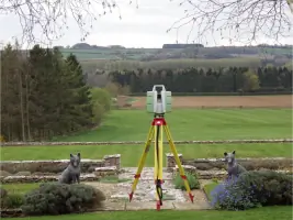
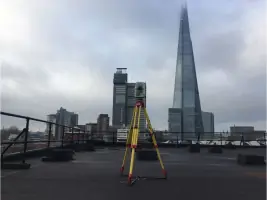
Cadmap is a highly professional land and building surveying company with over 30 years of experience in the construction industry. Specialising in measured building surveys, topographical surveys, and GPR utility detection, we serve clients across London, Surrey, Sussex, and the wider South of England. Our team utilises advanced technology including Leica robotic total stations, GPS systems, and 3D laser scanners to deliver precise digital survey data. As a TSA-approved practice, we adhere to the highest industry standards, providing services such as PAS128-compliant utility mapping, CCTV drainage surveys, and structural monitoring. With offices strategically located in London, Surrey, Brighton, and Southampton, we combine technical expertise with local knowledge to support architects, developers, and engineers. Our commitment to accuracy ensures clients receive reliable data for informed decision-making, while our investment in cutting-edge equipment maintains our position at the forefront of surveying innovation. We prioritise client satisfaction through tailored solutions that meet specific project requirements.
Services
Topographical Surveys
Measured Building Surveys
GPR Utility Surveys
CCTV Drainage Surveys
Structural Monitoring
3D Laser Scanning
Boundary Surveys
Hydrographic Surveys
Site Setting Out
BIM Modelling
Served areas
- Uk - London and South East
Details
- Year established: 2011
- Employees: 25
- Licensed
- Insured
Highlights and features
- Over 30 years of construction industry experience in surveying
- TSA-approved surveying practice with industry-leading standards
- Advanced technology including Leica laser scanners and GPS systems
- Accurate digital survey data for informed project decisions
- Strategically located offices covering London and the South of England
Associations and certifications
- The Survey Association
- PAS128
Payment methods
- Bank transfers
Services
Topographical Surveys
Our topographical surveys create detailed terrain models showing elevations, contours, and features. Using robotic total stations and GPS, we provide data for planning applications and construction projects. Surveys include digital terrain models, contour lines, and spot heights to support infrastructure development.
Measured Building Surveys
Measured building surveys capture precise structural dimensions using 3D laser technology. We produce floor plans, elevations, and BIM models for renovations and heritage conservation. Our surveys meet Land Registry requirements and support architectural design across London and the South.
GPR Utility Surveys
Ground Penetrating Radar (GPR) surveys locate buried utilities to PAS128 standards. We identify cables, pipes, and services using advanced detection equipment. This prevents damage during excavations and ensures safe site preparation for developers and contractors.
CCTV Drainage Surveys
CCTV drainage surveys map sewer systems and identify blockages using GPS-coordinated camera equipment. We provide condition reports and depth measurements for maintenance planning. Services cover London, Surrey, and Sussex with rapid deployment capabilities.
Structural Monitoring
Structural monitoring surveys track building movements using precision instruments. We install sensors to measure displacement and stress in critical infrastructure. This service supports safety assessments for high-rise buildings and historic structures across our operating regions.
People
Michael Brett
CEO
With over 30 years in surveying, Michael leads Cadmap's technical operations. He oversees survey standards and client relationships, ensuring precision in all projects.
Andy Finn
CEO
Andy manages Cadmap's strategic growth and service delivery. His expertise in geospatial technologies drives innovation across the company's surveying solutions.
Questions
What is a topographical survey?
A topographical survey maps physical land features and elevations, providing detailed data for construction and development projects.
What does a measured building survey include?
Measured building surveys capture precise dimensions of structures, including floor plans, elevations, and structural details for renovation or documentation.
What is a PAS128 utility survey?
PAS128 surveys locate underground utilities using GPR and detection equipment to meet British standards for safety and accuracy.
Do you offer 3D laser scanning services?
Yes, we provide 3D laser scanning for accurate building and site documentation using Leica RTC360 and P20 scanners.
Which areas do you cover?
We operate across London, Surrey, Sussex, Hampshire, Berkshire, and surrounding regions in southern England.
Are you a certified surveying practice?
Yes, we are approved by The Survey Association and follow PAS128 standards for utility detection and mapping.
Videos
Reviews (2)
John Barnes
Jul 14, 2013
Report
Cadmap undertakes our Land Surveys and Building surveys on many of our sites, the final product is great as well as the service. John.
Ian
Nov 05, 2011
Report
Having recently started using CADMap for our land surveying, we have been thoroughly impressed since the moment we brought them onboard. The level of service, professionalism and the quality of their work have been outstanding. I have no hesitation in recommending them to anyone thinking of using their services. Many Thanks