
Measured Precision
SJ Geomatics Ltd offers land, engineering, and specialist surveying services across the UK for residential, commercial, and infrastructure projects. The company supports clients from the initial feasibility and design stages through to construction and handover, providing accurate and construction-ready data with clear outputs, responsive communication, and dependable turnaround.The services provided by SJ Geomatics Ltd include topographical surveys, measured building surveys, utility and GPR surveys, CCTV surveys, and setting out and engineering support. Additionally, the company delivers advanced capture and modeling solutions, such as 3D laser scanning with BIM-ready models, drone surveys, and aerial mapping for efficient coverage of hard-to-access sites. Specialist services also include rebar scanning, bathymetric sonar surveys, and thermographic surveys, as well as producing Land Registry-compliant plans and offering AutoCAD services.
SJ Geomatics Ltd is a prequalified, accredited, and professionally aligned supplier, holding memberships with various organizations, including Builders Profile, Achilles, and Constructionline. The company is also accredited with ISO 27001, ISO 9001, and ISO 14001, with ISO 22301 and ISO 45001 currently in progress.
Whether a client requires a one-off survey or ongoing site support across multiple locations, SJ Geomatics Ltd provides reliable results that can be built upon.
Served areas
- Nationwide
Business details
- Year established: 2012
- Employees: 6
- Licensed
- Insured
Highlights and features
- Nationwide land and building surveys delivered with precision
- Professional friendly service with proven surveying expertise nationwide
- State-of-the-art equipment ensuring accurate high-quality survey results consistently
- Comprehensive surveying solutions from planning through construction stages
- Experienced surveyors trusted by public and private sector clients
- Cost-effective time-sensitive services tailored to project requirements nationwide
Associations and certifications
- Chartered ICES
- ISO9001
- ISO14001
- ISO27001
- ISO45001
- ISO22301
- Constructionline Gold
- Achilles
- Accredit
- Joscar
- SMAS - SSIP
- Arpas UK - The Drone Association
- Suffolk Chamber of Commerce
- Federation of Small Businesses
Payment methods
- Checks, Debit cards, Credit cards, Bank transfers
Services
Our topographical surveys form a critical foundation for informed development and land assessment. Using highly accurate on-site equipment, we capture detailed elevation and feature data across each site. Surveys are referenced to national grid coordinates at no additional cost. Technical drawings are produced in clear 2D or 3D formats. We focus on accuracy, efficiency, and dependable delivery.
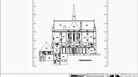 We provide Measured Building Surveys that support informed decision-making throughout planning and construction. Our experienced surveyors combine speed with precision, producing detailed internal and external surveys using modern 3D laser scanning technology. Output data can be supplied in digital or paper format, with accuracy meeting demanding professional standards and the specific expectations of every client.
We use advanced 3D laser scanning technology to create precise digital representations of structures and environments. The process captures comprehensive spatial detail, enabling flexible outputs such as models, drawings and visual imagery. By combining accuracy with efficiency, our surveys support effective planning, coordination and analysis while reducing time and cost compared with traditional methods.
We provide non-invasive underground surveys using RFL and GPR to form detailed, digitised images of buried features. Conductive metals are located via magnetic fields, while radar reflections reveal pipes, cables, voids and structural elements. Results are visualised on site for immediate clarity. Our skilled surveyors ensure dependable outputs that support safe planning and pre-construction analysis.
Our GPS Land Surveys provide accurate, real-time spatial data suitable for large-scale and complex sites. By utilising advanced GPS equipment, we collect high volumes of information efficiently, even where traditional sight lines are obstructed. The resulting data aligns with Ordnance Survey mapping, supporting informed decision making and long-term spatial analysis.
Our drone surveying service delivers rapid, high-quality aerial data to support planning, design, construction and asset management requirements. UAV surveys are effective across expansive sites and operational environments, particularly where ground access presents safety or practical constraints. Outputs may comprise georeferenced imagery, surface and terrain models, contours and detailed 3D representations. Information can be combined with ground control and traditional surveys and supplied in CAD or GIS-ready formats.
Our Setting Out service provides skilled engineers to accurately deliver construction and civil engineering works. We set out elements to design coordinates and levels, maintain robust site control, and carry out ongoing checks. Typical activities include foundations, drainage, structural frames and highways works, supported by clear communication with site teams to minimise rework.
Rebar Surveys
Report
Our Rebar Surveys accurately detect reinforcement within concrete through specialist non-invasive scanning methods. The service is routinely undertaken before drilling, cutting or fixing works to minimise structural risk. We verify reinforcement position, spacing and cover when records are unclear. Results are presented as marked-up outputs and an explanatory report for informed decision-making.
CCTV Surveys
Report
 Our CCTV Survey service offers a thorough inspection of drainage and pipework to evaluate condition, confirm system connectivity and highlight emerging defects. Advanced camera equipment allows us to identify problems including deformation, cracking, root intrusion, displaced joints, obstructions and structural damage. The surveys are widely used for pre-purchase assessments, asset condition reviews, drainage verification and construction monitoring. Reporting includes video evidence, inspection data and a structured condition report.
We deliver accurate, up-to-date land surveys to support planning, development, feasibility and design. Our experienced surveyors work across projects of varying scale, from individual plots to complex infrastructure. We advise on appropriate specifications and capture detailed site data. Each survey is tailored through close collaboration, ensuring reliable outputs aligned to your objectives.
CAD Bureau / AutoCAD Services
Report
Our CAD bureau delivers structured AutoCAD drawing services that support precise and well-managed project records. We integrate seamlessly with existing CAD frameworks, respecting established standards, templates and layering conventions. Typical work includes topographic and building drawings, as-built documentation, schedules, plan compliance, updates and standardisation. We also generate CAD drawings from survey data, issuing files in DWG, DXF and PDF formats.
Point Cloud Delivery
Report
Our point cloud delivery service provides high-density spatial datasets produced from terrestrial and aerial surveys. We register and coordinate scan data to agreed project controls before issuing files ready for design and BIM environments. Deliverables may include georeferenced point clouds, segmented datasets and supporting views, supplied in suitable formats with clear structure and version control.
We provide precise area calculations derived from our measured building and topographical survey data. This service supports land, buildings, rooms, gardens, and related spaces. Our surveyor also records levels to assist volume calculations for construction materials. Accurate measurements enable informed purchasing decisions, helping minimise excess materials and unnecessary costs.
People
Steve Jones TCinstCES
Director
Steve Jones is the Director of SJ Geomatics Ltd, a Member of ICES, and has over 30 years experience supporting construction, engineering and property projects with reliable surveying and geomatics services. Steve leads project delivery across the UK, ensuring survey outputs are accurate, clearly presented and aligned with design and site requirements, with a strong emphasis on quality, safety and responsive client support.
Reviews (1)
Andrew
Apr 27, 2025