Business Details
22 Years
experience
Expert Surveying Solutions for All Environments
Established in 2004, LandScope Engineering has become one of the UK's leading surveying companies specialising in integrated survey solutions above ground, below ground, and underwater. Our expert team includes members of the Chartered Institution of Civil Engineering Surveyors (MCInstCES) and Royal Institution of Chartered Surveyors (MRICS), combining over 20 years of industry experience with cutting-edge technology. In 2025, we joined the Celnor Group, a people-focused business offering technical and environmental solutions across diverse industries. Our commitment to innovation is demonstrated through our investment in advanced mobile mapping systems, ground-penetrating radar, and marine survey technologies. We deliver precise, reliable data for structural monitoring, utility mapping, and environmental assessments, serving clients across all sectors.Our highway survey vehicle reduces traffic management requirements while maintaining safety and efficiency. With 7,500+ successfully delivered projects, we maintain a strong reputation for quality-driven solutions. Our team's expertise extends to archaeological geophysics, pavement analysis, and marine asset inspections. We prioritise net-zero initiatives through carbon-efficient survey methods aligned with PAS2080 standards. Backed by rigorous marine safety certifications and a dedicated in-house technical team, we provide comprehensive geospatial data management solutions through platforms like Trimble 4D Control and U-GIS.
Services
Land Survey
Mobile Mapping
Structural Monitoring
Utility Mapping
Marine Inspection
Geophysical Survey
Pavement Analysis
Environmental Monitoring
Archaeological Geophysics
Hydrographic Surveys
Details
- Year established: 2004
Highlights and features
- 20+ years of specialist surveying experience in complex environments
- Chartered professionals with MCInstCES and MRICS accreditations
- Advanced mobile mapping systems operating at highway speeds
- Celnor Group membership ensuring technical and environmental expertise
- PAS2080-compliant carbon-efficient survey methodologies
Associations and certifications
- MCInstCES
- MRICS
- PAS128
- Celnor Group
Services
Mobile Mapping
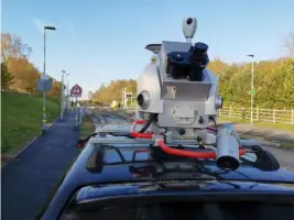
Our mobile mapping systems capture high-density LiDAR data and 360 imagery at highway speeds using the Leica Pegasus II Ultimate system. This technology enables rapid, safe data acquisition for topographical surveys, asset management, and digital twin modelling. The georeferenced datasets integrate with multiple sensors including GPR and pavement cameras, offering scalable solutions for highway, rail, and water environments while significantly reducing field time and carbon emissions.
Structural Monitoring
We provide real-time structural health monitoring using advanced sensors and Trimble 4D Control software for automated data analysis. Our systems track building settlement, bridge movement, and coastal erosion with millimetre precision using total stations, inclinometers, and wireless tiltmeters. The service includes real-time alerts via SMS/email for threshold breaches, supporting proactive maintenance of critical infrastructure while maintaining compliance with safety and regulatory standards across construction and operational phases.
Marine Inspection
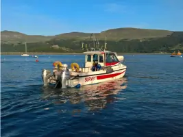
Our marine asset inspections combine multibeam sonar, scanning sonars, and ROV-deployed photogrammetry for comprehensive underwater assessments. We inspect ports, bridges, and flood defences using georeferenced 3D modelling that integrates with terrestrial data. The service includes tidal flow analysis, sediment monitoring, and environmental impact assessments, supported by MCA-coded vessels and RYA-certified surveyors ensuring operational safety in challenging coastal environments while delivering actionable data for asset management systems.
Utility Mapping
Our mobile GPR systems map underground utilities at highway speeds using Kontur DXG-Series antenna arrays integrated with GNSS positioning. This PAS128-accredited service identifies buried services, pavement defects, and voids with centimetric accuracy while eliminating traffic management requirements. The data integrates with surface LiDAR and photogrammetry for complete 'above and below ground' visualisation, supporting infrastructure planning and reducing excavation risks through precise 3D utility location mapping.
Geophysical Survey
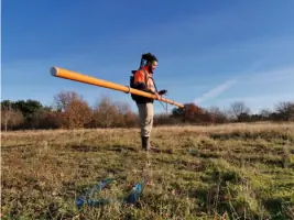
We deploy non-intrusive geophysical techniques including GPR, electrical resistivity tomography, and seismic surveys for subsurface investigations. Our services detect buried structures, archaeological features, and geological variations across land and marine environments. The technology supports highway analysis, environmental assessments, and mining operations through high-resolution subsurface imaging that minimises ecological disruption compared to traditional borehole methods, while delivering data for BIM integration and asset management platforms.
Questions
What survey environments do you specialise in?
We provide integrated survey solutions across above-ground, subterranean, and underwater environments, including highways, marine assets, and archaeological sites.
How do your mobile mapping systems improve efficiency?
Our mobile mapping systems capture data at highway speeds, reducing traffic management requirements while maintaining safety and delivering high-resolution geospatial data.
What accreditations do your surveyors hold?
Our team includes members of the Chartered Institution of Civil Engineering Surveyors (MCInstCES) and Royal Institution of Chartered Surveyors (MRICS).
How do you ensure environmental compliance?
We follow PAS2080 standards for carbon-efficient surveys and employ non-intrusive geophysical techniques to minimise environmental impact.
What structural monitoring capabilities do you offer?
We provide real-time structural monitoring using high-precision instruments including total stations, inclinometers, and wireless tiltmeters for buildings and infrastructure.
What marine survey services are available?
Our marine services include asset inspections, hydrographic surveys, environmental monitoring, and geophysical assessments using sonar, magnetometry, and ROV systems.