Business Details
28 Years
experience
Underground Mapping & Utility Survey Specialists
GEOTEC Surveys has been a trusted leader in underground mapping and utility detection for over 25 years. Our expertise spans advanced geophysical techniques, including ground-penetrating radar (GPR) and topographical surveys, serving diverse sectors such as energy, railways, and public infrastructure. Our multi-disciplined teams hold accreditations like ISO9001:2015, Achilles UVDB, and RISQS, ensuring adherence to the highest industry standards. We prioritise client collaboration, delivering tailored solutions that integrate statutory records with cutting-edge technology.Our commitment to safety and precision is reflected in our NRSWA, EUSR, and sector-specific certifications. Operating nationwide across the UK and Ireland, we combine technical excellence with a client-centric approach to mitigate risks and enhance project outcomes. Our proven track record includes complex projects for MOD sites, healthcare facilities, and major transport hubs, underpinned by a 100% audit success rate in critical accreditations.
Services
PAS 128 Surveys
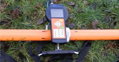
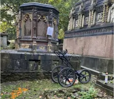
GPR Surveys
Utility Mapping
Topographical Surveys
Desktop Utility Studies
Details
- Year established: 1998
Highlights and features
- 25+ years of expertise in underground mapping and utility detection.
- Manufacturer-independent approach ensures optimal technology for each task.
- Lead surveyors oversee all results, guaranteeing accountability and accuracy.
- Accredited by ISO9001, Achilles UVDB, and RISQS for industry-leading standards.
- Nationwide service across the UK and Ireland, including complex sites.
Associations and certifications
- ISO9001:2015
- Achilles UVDB
- Verify
- RISQS
- Constructionline Gold
- The Survey Association (TSA)
- Euro GPR
What people say
Excellent work
Highest quality
Professional in their duties
Confidence and safety
Satisfied customers
Services
PAS 128 Surveys
PAS 128 Surveys detect and map underground utilities to industry standards, ensuring compliance and safety. We use radio frequency detection and GPR to identify metallic and non-metallic services. Our surveys reduce risks during construction by providing accurate, detailed subsurface data for design and planning.
GPR Surveys
Ground Penetrating Radar (GPR) Surveys provide high-resolution images of subsurface features, including voids, utilities, and structural elements. Our vehicle-mounted and handheld systems adapt to diverse environments, offering non-invasive insights for infrastructure and construction projects.
Topographical Surveys
Topographical Surveys capture detailed terrain and surface features using RICS-standard methods. These surveys support project planning by integrating with underground data, ensuring comprehensive site analysis for developments and infrastructure projects.
Desktop Utility Studies
Desktop Utility Studies compile statutory records into layered digital maps, simplifying complex data for project feasibility. This cost-effective service informs early-stage planning by consolidating utility information from multiple providers into a single, actionable resource.
Sub-Surface Consultancy
Sub-Surface Consultancy offers expert guidance on survey methodologies and data interpretation. Our team advises on optimal techniques for detecting hidden risks, ensuring clients select the right solutions for challenging underground conditions and regulatory compliance.
People
Brian Payne
Director
With 25+ years in geophysics, Brian leads innovation in underground mapping technologies. His expertise in combined methodologies drives GEOTEC's market leadership and client satisfaction through repeat projects.
Julian Sperling
Operations Manager
Julian leverages extensive sales experience to prioritise client needs, ensuring clear communication and high-quality service delivery. His relationship-building fosters long-term partnerships across key accounts.
David Todd
Survey Manager
David co-founded GEOTEC and specialises in geophysical and utility mapping. His deep technical knowledge spans BIM integration and PAS 128 standards, supporting innovation in Northern Ireland and beyond.
Luke Hammond
Senior Project Manager
Luke oversees complex surveys and client solutions, drawing on a decade of field experience. He manages risk assessments and quality checks, ensuring compliance and precision in every project.
Tom Skilleter
Senior Project Consultant
Tom bridges client requirements with tailored survey solutions, managing tenders and compliance. He updates stakeholders on GEOTEC's innovations through case studies and industry engagement.
Questions
What industries do GEOTEC Surveys serve?
We work across energy, railways, public sector, healthcare, housing, telecommunications, and airports, providing tailored underground mapping solutions.
How do GEOTEC Surveys ensure data accuracy?
We use multi-method approaches (GPR, radio frequency) and cross-reference statutory records, overseen by lead surveyors accountable for quality and compliance.
Can GEOTEC handle urgent or complex sites?
Yes, we specialise in high-risk environments like MOD sites and hospitals, with teams certified for water safety, NRSWA, and rail sectors.
What accreditations does GEOTEC hold?
We maintain ISO9001:2015, Achilles UVDB, RISQS, Constructionline Gold, and memberships in The Survey Association and Euro GPR.
Do GEOTEC Surveys operate outside the UK?
We primarily cover the UK and Ireland but have undertaken projects in Europe and the Middle East as required.
