Elevate your projects with precision
CADMAP Limited is a leading UK surveying and geomatics company founded by Michael Brett in 2011. Specialising in topographical land surveys, measured building surveys, PAS 128 utility mapping, CCTV drainage surveys, laser scanning and BIM modelling, CADMAP delivers highly accurate survey solutions for architects, engineers, developers, infrastructure companies and government organisations throughout London, the South East and across the UK.Under the leadership of Michael Brett, CADMAP has grown from a small surveying business into an award-winning company employing a large multidisciplinary team of surveyors, CAD technicians and utility mapping specialists. Michael began his surveying career in 1999 and built extensive expertise in land surveying, geomatics, CAD management and digital marketing before establishing CADMAP. His vision combined technical excellence with innovative online marketing strategies, helping position the company as one of the most recognised surveying brands in Britain.
CADMAP is widely recognised for delivering complex surveying projects using advanced technology including Leica RTC360 laser scanners, GPS systems, robotic total stations and ground penetrating radar (GPR) equipment. The company produces high-quality AutoCAD drawings, Revit BIM models and detailed utility and drainage reports for residential, commercial, industrial and infrastructure developments.
The company has worked for a prestigious range of clients including BBC television productions, Mace, Arcadis, Barratt Homes, Cala Homes, Bellway Homes, Kier Group and international private clients including royal family developments and overseas projects. CADMAP has undertaken projects across the UK as well as internationally, including surveying work in France, Ireland and the Falkland Islands.
CADMAP is also recognised for its expertise in utility surveying and underground mapping through PAS 128 compliant GPR surveys, helping developers and contractors reduce construction risk and avoid costly underground service strikes. Its CCTV drainage surveying division provides comprehensive drainage reports with GPS referenced asset data, invert levels, flow direction analysis and condition assessments.
With strong health and safety accreditations, 10 million professional indemnity insurance and a reputation for accuracy, reliability and innovation, CADMAP continues to be regarded as one of the leading surveying companies serving architects, engineers and developers throughout the UK.
Served areas
- The whole UK - London, Surrey, Sussex, South East
Business details
- Year established: 2011
- Employees: 25
- Licensed
- Insured
Highlights and features
- Topographical Surveys
- GPR Surveys
- Measured Building Surveys
- BIM Scanning
- Rebar Scanning
- Concrete Scanning for depth and Rebar
- 3D Scanning
- Revit Models
- Drainage Surveys
- CCTV Drainage Surveys and Jetting
Associations and certifications
- Full Member the TSA - The Survey Association
- CICES
Payment methods
- Bank transfers
Services
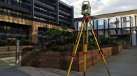 We carry out accurate topographical surveys to support building development, land management, and design projects. By recording land levels and site features in their true positions, we help clients make informed decisions during the planning process. Our surveyors use professional Leica total stations and are trained across all aspects of land surveying and site setting out. We also maintain current industry certifications required for secure site access.
 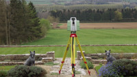 We deliver comprehensive measured building survey services designed to meet RICS requirements. Using advanced equipment, we capture accurate building data to produce floor plans, elevations, sections, and CAD plans. We work closely with architects and large developers across residential and commercial projects. All survey data is provided in digital formats including DWG, DXF, and PDF. Our approach ensures dependable documentation for planning and design purposes.
 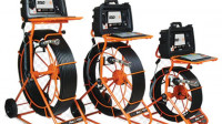 Our CCTV drainage surveys are undertaken across London and surrounding counties with consistent professional standards. We produce detailed sewer condition reports supported by precise inspection data. Specialist surveyors evaluate underground drainage systems to identify structure, flow direction and pipe dimensions. All results are documented clearly to reflect the condition of each surveyed system.
 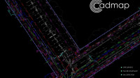 PAS128 GPRS surveys are produced by Cadmap Limited for clients from homeowners to blue chip. A GPR survey is a non-invasive technique to identify and map underground features. Radar pulses are transmitted into ground and reflected by electrical property variations. Data is processed into images and 3D maps providing outputs for construction, utilities, archaeology and drainage.
  Cadmap Ltd provides professional boundary surveys for clients requiring accurate land delineation. These surveys depend on experienced surveyors and specialist instruments, as tape and handheld devices alone cannot deliver the required precision. We undertake work for boundary disputes, registration with the Land Registry, and accurate measurement of land areas. Our deliverables include structured reports and supporting boundary plans.
 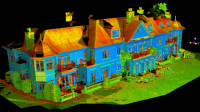 We process point cloud data using Leica Cyclone software for registration and editing. Unwanted elements such as trees are removed and building sections created. Data is then imported into Leica Cloudworx for AutoCAD 2016 for drawing production. Outputs may be visualised using Revit and 3DS Max.
Reviews (7)
Mike Brett
May 23, 2026
We used CADMAP Limited for a combination of topographical and utility surveys on a complex development site, and the service was excellent from start to finish. The team was professional, responsive, and clearly very experienced in handling detailed survey requirements.
The deliverables were highly accurate and well presented, including clear AutoCAD drawings and comprehensive utility mapping that made coordination with our design team straightforward. Communication throughout the project was consistent, and any queries were dealt with quickly and efficiently.
Overall, CADMAP provided a reliable and high-quality service, and I would have no hesitation in recommending them for topographical, measured building, or PAS 128 utility surveys.
Julija Kivrina
May 23, 2026
Azid Ahmed
May 23, 2026
Andy Skinner
Feb 16, 2026
Wojciech Banas
Dec 21, 2023
Oliver Perceval Architects
Dec 15, 2023
Darren Holmes
Sep 30, 2023