
Business Details
43 Years
experience
Professional Land Surveyors in Hampshire
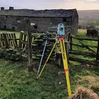
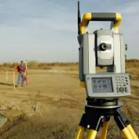
Established in 1983, Sterling Surveys provides professional land surveying services for topographic, architectural, and engineering projects. As an independent company owned by staff and directors, we operate throughout the United Kingdom and internationally from offices in London and Yorkshire. Our team comprises qualified professionals who utilise the latest survey equipment to deliver accurate data tailored to client needs. We adhere to rigorous standards as a RICS-regulated and SSIP-accredited organisation, prioritising health and safety in all operations. All commissions are conducted by our in-house staff, ensuring consistency and expertise without reliance on freelance or agency personnel. Our surveyors carry company-issued photo-identity cards for transparency during fieldwork.Directors and senior staff bring extensive experience in managing complex overseas projects, supported by a commitment to innovation and precision. We specialise in boundary disputes, 3D laser scanning, measured building surveys, and verified views, serving clients across diverse sectors. Our reputation is built on over 400 expert witness reports for boundary disputes over 15 years, demonstrating our authority in resolving legal challenges. Clients benefit from our technical proficiency, including high-accuracy levelling, photogrammetry, and inland hydropgraphic surveys, delivered through a client-centric approach focused on reliability and clarity.
Services
Topographic Surveys
Boundary Disputes
Measured Building Surveys
Verified Views (VVM)
Setting-Out Services
3D Laser Scanning
Inland Hydropgraphic Surveys
Monitoring Services
Highway & Railway Surveys
Aerial Surveys
Details
- Year established: 1983
Highlights and features
- Established in 1983 with extensive surveying expertise
- RICS-regulated and SSIP-accredited for quality assurance
- In-house team ensures consistent, reliable service delivery
- Specialists in boundary disputes with 400+ expert reports
- Advanced technology for 3D laser scanning and verified views
Associations and certifications
- RICS
- SSIP
- RISQS
- PTS
- CSCS
Services
Topographic Surveys
Sterling Surveys conducts detailed topographic surveys to map natural and man-made features, aiding construction, drainage, and landscaping projects. We deliver data in 2D DWG files or 3D models, including spot levels, contours, and infrastructure details. Our surveys meet OS datum standards, ensuring accuracy for design and planning purposes.
Boundary Disputes
We resolve boundary conflicts through precise measurements and CPR35-compliant reports, combining physical evidence with historical records. Our RICS-accredited experts have produced over 400 court-admissible reports, offering clear plans for mediation or litigation. Services include site visits, evidence analysis, and expert witness testimony.
3D Laser Scanning
Using high-definition laser scanning, we create detailed 3D point clouds for structures, enabling BIM integration and deformation analysis. This method reduces safety risks and time constraints, providing scalable data for architectural, engineering, and heritage projects with millimetre precision.
Measured Building Surveys
We produce accurate floor plans, elevations, and sections for buildings of all complexities, from historic sites to modern infrastructure. Data is delivered in 2D DWG or 3D formats, capturing fixtures, fittings, and architectural details to support renovations, valuations, or compliance assessments.
Verified Views (VVM)
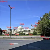
Sterling Surveys supplies survey data for verified views, showing proposed developments in their surroundings. These images support planning applications and inquiries, created using precise measurements to ensure accuracy for regulatory and stakeholder presentations.
Questions
What surveying services does Sterling Surveys offer?
We provide topographic surveys, boundary disputes resolution, measured building surveys, 3D laser scanning, verified views, and specialist services for highways, railways, and hydropgraphic projects.
Are your surveyors accredited by professional bodies?
Yes, we are RICS-regulated, SSIP-accredited, and verified by RISQS, with staff holding PTS and CSCS certifications.
Can you handle international surveying projects?
Yes, we operate globally from offices in London and Yorkshire, with directors experienced in managing overseas projects.
How do you resolve boundary disputes?
We produce accurate plans and CPR35-compliant reports, having completed over 400 expert witness reports for legal cases.
What technology do you use for surveys?
We utilise 3D laser scanning, photogrammetry, GPS positioning, and high-accuracy levelling equipment for precise data collection.
Reviews (3)
James Gustard
Jan 12, 2022
Report
Sterling Surveys provided a detailed topographic survey of our plot to aid with construction plans. They also provided an excellent determined boundary report that was successfully added to our title to resolve a boundary dispute. The Judge at the First Tier Tribunal (Land Registration) was very complimentary of Sterling Survey's work.
Eleanor Allen
Jan 11, 2021
Report
Andrew Lynch is an unprofessional and dishonest man, he cannot be trusted to do a good job. If you expect him to perform well as an expert witness, think again. Would not recommend and suggest avoiding like the plague!
Cherry Mills
May 25, 2019
Report
I have been using Sterling Surveys to survey gardens for my garden design business for many years. They are always very efficient, organised and professional. They are also delightful people to do business with and I would recommend them for any surveying work.